In order to use this Interactive version of the Exeter City Council Local Plan to its fullest potential it is strongly recommended that the user reads this guide before proceeding.
The Adopted Exeter City Local Plan comprises a Written Statement and the Proposal Maps.
By clicking on the ‘Written Statement - Contents’ link in the header bar you will be able to view a complete list of all the chapters and appendices contained within the Local Plan. Selection of a chapter or appendix will open the Written Statement, scrolled to the appropriate position. You can scroll through the chapter using either the scroll keys on your keyboard, the scroll bar to the right of the screen, or by the scroll wheel on your mouse (if applicable). You can move between chapters by using the buttons at the bottom of the chapter or by reselecting from the contents menu.
The ‘Written Statement - Policies’ link in the header bar will display a full List of Policies in chapter order. Selection of a policy will open the Written Statement, scrolled to the appropriate position.
The Proposals Maps can be accessed by clicking on the ‘Proposals Maps’ link in the header bar. There are 3 ways to access the maps - the user may either select a map from the list, search for a postcode or street or click on the 'Exeter City Environs' map image. Each method will take the user to an opening image of the Proposals Map - click on the image to progress into the 'Map Window'.
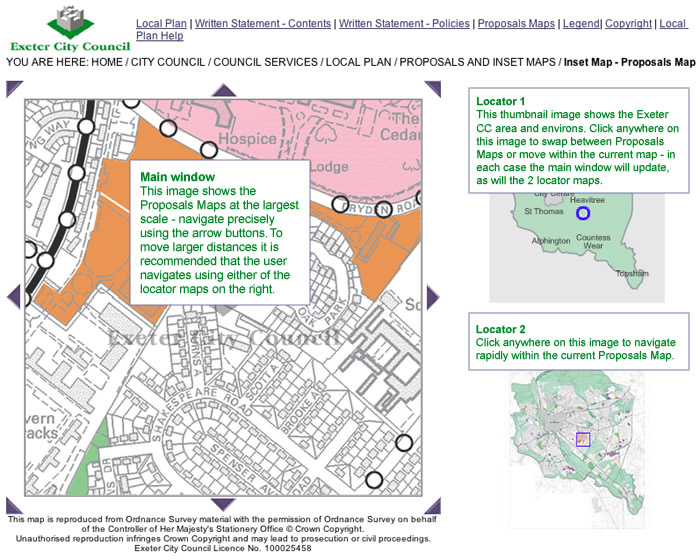
In the Main Map Window (shown below) the 'locator' map on the top right shows the geographical location of the main map image within Exeter City. The lower 'locator' map shows the geographical location of the main map image within the Proposals or City Centre Inset Map. You can navigate around the currently selected map sheet or inset map by using the arrows located around the main map image. By clicking on these, the next ‘map tile’ in that direction will appear. For moving larger distances you can click on the ‘Locator’ Map to the right.
Please note:
i) clicking on the lower location map will only move you within the current inset map i.e. by clicking on the 'grey' area on the lower locator image, you remain within that inset. To swap between the Proposals or City Centre Inset Map use the top locator or return to the 'Proposals Maps' page to reselect an inset map/location.
ii) any movement of the main map image will be correspondingly matched by the blue locator on the ‘Locator’ Map(s).
By hovering your mouse over the main map image a 'tip tag' indicating what policies apply to the relevant position of your mouse. By clicking at that position you will open a new window with a listing of all policies for that location. By selecting each one in turn the relevant text will appear. Use the back button in your web browser to return to the listing.
The header bar contains a link to the ‘Key’ page. On selection a new window will open showing all the colours and styles used in the mapping to represent the policies featured within the Local Plan. This is a useful guide when identifying policies shown on the maps. It is recommended that you leave this window open or minimised whilst navigating the mapping section of the Local Plan.
You can right click on any web page and select print (left click) and if you wanted to print a selection, you highlight the selection, then right click then select Print, Selection, OK. As an alternative to this you can highlight the information you wish to print, right click and select copy and then paste this into Microsoft Word.