9.1 At the heart of this Local Plan is a sustainable development strategy that seeks to concentrate new development in the urban area by maximising the re-use of previously-developed land and the conversion and re-use of existing buildings wherever possible. Essential to any sustainable development strategy are the policies and proposals relating to transport. The location and type of development directly affect the amount of travel to and from it and the mode of that travel. In turn the provision of transport infrastructure can influence patterns of development.
9.2 Government policy (Planning Policy Guidance Note 13: Transport) aims to promote more sustainable transport schemes, promote accessibility to jobs, shopping, leisure facilities and services by public transport, walking and cycling, and reduce the need to travel, especially by car. In particular it aims to ensure that planning and transport are integrated and advises that development should be concentrated on the urban areas in locations which are highly accessible by sustainable transport.
9.3 PPG 13 introduces the requirement that Transport Assessments should be submitted alongside planning applications which have significant transport implications. These should illustrate accessibility to the site by all modes and the likely modal split of journeys to and from the site, together with proposed measures, such as green travel plans to improve access by alternatives to the car. Maximum levels of parking should be set for many developments and there should be no minimum levels. A key element is the preparation of Local Transport Plans which will set the strategic framework for travel and transport over a 5 year period and allocate capital funding to highway authorities for transport schemes. The Local Plan and the Local Transport Plan are expected to be consistent.
9.4 These aims are closely reflected in Regional Planning Guidance (RPG10) which emphasises the need to focus development on the Principal Urban Areas (including Exeter). Within the PUAs development should be located where there is a good choice of travel by sustainable transport or where the development proposals will provide choice. Transport accessibility criteria and maximum parking standards are identified.
9.5 The Structure Plan First Review sets out the intention to develop a comprehensive and integrated transport strategy consistent with the need to reduce travel and encourage alternatives to the private car.
9.6 Devon County Council is preparing a transportation strategy for the sub-region centring on Exeter. The strategy will, in particular, consider the importance of growth arising from proposed major developments close to Exeter, in East Devon, i.e. a new community, Exeter Airport expansion and Skypark employment development. This work is taking place in partnership with neighbouring District Councils.
9.7 In parallel with this work the City Council has reviewed its transport strategy. It is recognised that the radial routes in the City are already at capacity in the peak hours and the resultant congestion affects all vehicles, including buses and commercial traffic. If no action is taken to reduce growth, peak hour traffic congestion will worsen, the peak hours will lengthen and the environmental nuisance and safety issues along rat runs will worsen. The strategy therefore aims to minimise the need for travel and encourage the use of sustainable alternatives, especially public transport.
9.8 In line with Government policies on sustainable transport, permission for development and transport measures should have regard to the hierarchy of modes which has been expanded from that set out in the Structure Plan. The expanded list recognises the special needs of people with mobility problems, acknowledges that taxis and coaches are a relatively sustainable form of transport and divides car users into different categories, with shoppers and business users having priority over car borne visitors and commuters. In assessing proposals, the nature and location of the development will be taken into account.
9.9 Key to the overall approach is the need to locate development in places that are, or are capable of being, well served by public transport and other sustainable modes. The aim is to ensure that a significant proportion of all journeys attracted to major new non-residential development will be on foot, by cycle or public transport and that residents of housing schemes will be within walking distance of local facilities and, in respect of major schemes, will have access by sustainable transport to a range of other facilities. Schedule 1 provides guidance.
9.10 Transport Assessments should be submitted for all developments with significant transport implications. The coverage and detail of such assessments will depend on the scale of development and the extent of transport implications. Implementation of the proposals arising from the assessments, which may include the provision of new infrastructure, support for bus services, etc. will be secured through planning conditions and planning agreements. For larger developments a travel plan may be required. The DTLR are preparing best practice guidance. The City Council intends to publish further advice on the site threshold for the requirement to submit a transport assessment.
9.11 In some instances it will not be possible to provide facilities from one development alone. In these cases, commuted payments will be sought and pooled to provide facilities. Commuted payments will also be used to enhance existing waiting and information facilities for public transport.
9.12 In general it is expected that developers of peripheral sites will find that they must provide more infrastructure and support for public transport than has previously been required. In contrast, developers of sites in the City Centre will find that their sites are already accessible and little extra will be required to meet the targets.
9.13 The County Council, through its Local Transport Plan, will seek to ensure that the complementary provision of public transport, cycle routes and other measures, designed to encourage a switch in mode away from the private car, will be implemented in association with new development.
T1: DEVELOPMENT SHOULD FACILITATE THE MOST SUSTAINABLE AND ENVIRONMENTALLY ACCEPTABLE MODES OF TRANSPORT, HAVING REGARD TO THE FOLLOWING HIERARCHY:
1. PEDESTRIANS
2. PEOPLE WITH MOBILITY PROBLEMS
3. CYCLISTS
4. PUBLIC TRANSPORT USERS
5. SERVICING TRAFFIC
6. TAXI USERS
7. COACH BORNE VISITORS
8. POWERED TWO WHEELERS
9. CAR BORNE SHOPPERS
10. CAR BORNE COMMERCIAL/ BUSINESS USERS
11. CAR BORNE VISITORS
12. CAR BORNE COMMUTERS.
T2: IN ACCORDANCE WITH THE ACCESSIBILITY CRITERIA SET OUT IN SCHEDULE 1: RESIDENTIAL DEVELOPMENT SHOULD BE LOCATED WITHIN WALKING DISTANCE OF A FOOD SHOP AND A PRIMARY SCHOOL AND SHOULD BE ACCESSIBLE BY BUS OR RAIL TO EMPLOYMENT, CONVENIENCE AND COMPARISON SHOPPING, SECONDARY AND TERTIARY EDUCATION, PRIMARY AND SECONDARY HEALTH CARE, SOCIAL CARE AND OTHER ESSENTIAL FACILITIES.
NON RESIDENTIAL DEVELOPMENT SHOULD BE ACCESSIBLE WITHIN WALKING DISTANCE AND/OR BY BUS OR RAIL TO A MAJORITY OF ITS POTENTIAL USERS.
SCHEDULE 1 : ACCESSIBILITY CRITERIA
WALKING DISTANCES |
||
FACILITY |
TARGET DISTANCE |
MAXIMUM DISTANCE |
FOOD SHOP |
500M |
1000M |
PRIMARY SCHOOL |
500M |
1000M |
OTHER FACILITIES |
750M |
1000M |
BUS STOP |
400M |
500M |
RAIL STATION |
- |
800M |
TRAVEL TIMES |
||
FACILITY |
PUBLIC TRANSPORT TRAVEL TIME IN MINUTES |
CAR TRAVEL TIME IN MINUTES |
SHOPPING |
30 |
20 |
EDUCATION |
30 |
20 |
OTHER NON-RESIDENTIAL FACILITIES |
40 |
25 |
FOR RESIDENTIAL DEVELOPMENT THE DISTANCES DEFINE THE MAXIMUM WITHIN WHICH FACILITIES ARE CONSIDERED TO BE WITHIN WALKING DISTANCE OF THE DEVELOPMENT AND THE TRAVEL TIMES DEFINE THE MAXIMUM WITHIN WHICH FACILITIES ARE CONSIDERED TO BE ADEQUATELY ACCESSIBLE BY PUBLIC TRANSPORT. |
FOR NON RESIDENTIAL DEVELOPMENT THE WALKING DISTANCES DEFINE THE PEDESTRIAN CATCHMENT AREA AND THE TRAVEL TIMES DEFINE THE RELATIVE CATCHMENT AREAS BY PUBLIC TRANSPORT AND BY CAR. PUBLIC TRANSPORT TRAVEL TIMES INCLUDE WALKING TIME TO AND FROM STOPS/STATIONS. CAR TRAVEL TIMES INCLUDE WALKING TIME AND PARKING TIME. |
FOR PUBLIC TRANSPORT TO BE ADEQUATE IT SHOULD: |
|
|
|
SUGGESTED IDEAL FREQUENCIES FOR THE URBAN AREA OF EXETER WOULD BE: |
|
|
IDEAL FREQUENCIES OF SERVICES OPERATING TO AND FROM OUTSIDE THE URBAN AREA |
|
|
9.14 Developers will be expected to safeguard the existing or proposed cycle and pedestrian networks. Opportunities should be taken to provide new and enhanced routes to local shops, schools, places of work and other key destinations so that users are encouraged to walk and cycle rather than drive. Routes should be of good quality, direct and comfortable. Appropriate cycle parking must be provided within developments. Schedule 2 provides guidance. These standards distinguish between the need for secure long stay parking for employees and short stay cycle parking for visitors. Where more than 20 people are employed facilities for washing and changing should be provided. Development which does not adequately provide for the pedestrian or cyclist will not be acceptable.
9.15 The layout of new development is crucial if car dependency is to be reduced and the use of public transport encouraged. Provision in large developments must be made for buses to run through or alongside the site with good pedestrian connections. Developers will be expected to provide facilities for bus travel such as carriageways of sufficient width, bus lay-bys, turning circles and bus shelters. Where appropriate, access to rail stations should be maximised and, in some cases, new rail stations should be provided in consultation with the train operating companies and the Strategic Rail Authority or successor authority.
9.16 The particular needs of people with disabilities also needs to be catered for. Convenient parking spaces should be identified so that employees and visitors are able to park close to their destinations. Dropped kerbs and ramps may also be needed to link parking/drop off points with the entrance to the development.
T3: DEVELOPMENT SHOULD BE LAID OUT AND LINKED TO EXISTING OR PROPOSED DEVELOPMENTS AND FACILITIES IN WAYS THAT WILL MAXIMISE THE USE OF SUSTAINABLE MODES OF TRANSPORT. PROPOSALS SHOULD ENSURE THAT:
(a) ALL EXISTING AND PROPOSED WALKING AND CYCLE ROUTES ARE SAFEGUARDED OR THAT ALTERNATIVE REASONABLY CONVENIENT ROUTES ARE PROVIDED;
(b) SUITABLE CYCLE PARKING PROVISION IS PROVIDED IN ACCORDANCE WITH THE STANDARDS SET OUT IN SCHEDULE 2;
(c) WHERE MORE THAN 20 PEOPLE ARE EMPLOYED FACILITIES FOR SHOWERING AND CHANGING ARE PROVIDED;
(d) FULL ACCOUNT IS TAKEN OF THE NEEDS OF BUS OPERATION THROUGH AND ALONGSIDE NEW DEVELOPMENT BY THE PROVISION OF LAY-BYS, ROADS AND OTHER ASSOCIATED FACILITIES;
(e) WHERE APPROPRIATE, PEDESTRIAN AND CYCLING LINKS ARE PROVIDED TO EXISTING OR PROPOSED RAIL STATIONS;
(f) THE PARTICULAR NEEDS OF PEOPLE WITH DISABILITIES ARE TAKEN INTO ACCOUNT.
SCHEDULE 2 : CYCLE PARKING STANDARDS
LAND USE |
STANDARD |
|
GENERAL RETAIL |
1 PER 45M2 FOR CUSTOMERS + 1 PER 200M2 FOR STAFF |
|
RETAIL WAREHOUSING OR DIY STORES |
1 PER 90M2 FOR CUSTOMERS + 1 PER 400M2 FOR STAFF |
|
PUBS, RESTAURANTS, CLUBS |
1 PER 10M2 |
|
OFFICES, FINANCIAL AND PROFESSIONAL SERVICES |
1 PER 250 M2 UNDER COVER FOR STAFF + CUSTOMER PARKING 1 PER 1,000M2 |
|
GENERAL INDUSTRY |
2 SPACES + 1 PER 400M2 |
|
WAREHOUSING |
2 SPACES + 1 PER 400M2 UP TO 1,000M2 THEREAFTER 2 SPACES + 1 PER 800M2 |
|
HOTELS AND GUEST HOUSES |
1 STAFF SPACE PER 10 BEDROOMS + 1 VISITOR SPACE PER 10 BEDROOMS |
|
THEATRES/CINEMAS AND ASSEMBLY HALLS |
1 SPACE PER 5 SEATS OR 10M2 OF PUBLIC FLOORSPACE AND 1 STAFF SPACE PER 100 SEATS |
|
EDUCATION |
1 SPACE PER 10 STAFF + 1 SPACE PER 5 STUDENTS OVER 11 |
|
| HEALTH | ||
| - HOSPITALS | 1 SPACE PER 10 BEDS | |
- HEALTH CENTRES |
1 SPACE PER 3 CONSULTING OR TREATMENT ROOMS |
|
LIBRARIES AND MUSEUM |
1 SPACE UNDER COVER PER 250M2 FOR STAFF, 1 SPACE PER 100M2 FOR VISITORS |
|
SPORTS/RECREATION |
1 SPACE PER 100 SEATS + 1 SPACE FOR EVERY 10 PLAYERS OR USERS + CAPACITY FOR STAFF |
|
SWIMMING POOLS/ICE RINKS OR HEALTH CLUBS |
1 SPACE PER 5M2 ACTIVE FLOOR AREA (I.E. POOL/RINK AREA) |
|
MARINAS |
1 SPACE PER 2 BERTHS |
|
CAMPING AND CARAVAN SITES |
1 SPACE PER PITCH + 1 PER 15 PITCHES FOR VISITORS |
|
| RESIDENTIAL | 1 SPACE PER 1-2 BED DWELLING | |
| DWELLINGHOUSES (NO GARAGE) | 2 SPACES PER 3 OR 3+ BED DWELLING | |
WITH GARAGE |
AS ABOVE, BUT CAN BE ACCOMMODATED IN GARAGE |
|
FLATS ABOVE SHOPS |
1 COVERED SPACE/FLAT |
|
MULTI-OCCUPATION/BEDSIT/STUDENT |
1 SPACE PER UNIT |
|
SHELTERED HOUSING |
1 SPACE PER 5 STAFF |
|
9.17 Walking is an easy and important way of retaining health and fitness. Typically 27% of all journeys are under a mile long of which 80% are on foot. Improving conditions for pedestrians is an important way of increasing the proportion of shorter journeys that are made on foot.
9.18 The City and County Councils have been working with national charity, Sustrans, on an innovative project to encourage more walking as a sustainable mode of transport. This project has sought to identify a network of key routes linking residential areas with significant destinations like shops, schools, universities, hospitals and employment areas. A programme of work has been developed to ensure that these routes are attractive, comfortable, well maintained and safe. Implementation will be mainly through the County Council's Local Transport Plan.
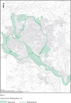
9.19 As part of this work a circular walking route around the city, known as the ‘green circle'(see 7.25 and Plan 2) has largely been implemented. Most of the route is made up of existing rights of way and permissive paths. Ongoing improvements to the route will be carried out. The design and layout of developments which are proposed across or adjacent to the ‘green circle' should take the route into account.
9.20 Pedestrian routes must be designed to include the provision of dropped kerbs and signing. They must be direct, well lit and overlooked where possible. Where they cross busy roads, the conflict with traffic and delay to pedestrians will be minimised by the provision of appropriate crossing aids like zebra or puffin crossings.
9.21 A major improvement in the pedestrian environment is proposed for the core of the City Centre (see 14.6 – 14.10, Policy KP1).
9.22 A wider programme of improvements will also be sought through the implementation of this Plan's provisions and through the Local Transport Plan.
T4: A CIRCULAR WALKING ROUTE WILL BE ESTABLISHED AROUND THE CITY WHICH WILL CONSIST OF EXISTING PUBLIC RIGHTS OF WAY AND OTHER PERMISSIVE PATHS (PLAN 2).
9.23 The City Council's Transportation Strategy sets out a series of objectives ‘to make cycling more attractive and encourage its use for appropriate journeys, especially as an alternative to the private car'. The strategy aims to promote the benefits of cycling to the wider community and increase the levels of cycling in line with national targets set by the Government, which is to treble the number of cycle trips by 2010 from a 2000 base.
9.24 There is potential for many more journeys (up to 5 miles) to be undertaken by bicycle but potential cyclists are put off by fears for their safety as a result of the speed and domination of the road network by motorised traffic. Where cycle routes have been provided in a linked and coherent way (a comprehensive network), cycle use has increased. This means that the particular needs of cyclists, including the protection and expansion of the existing cycle network, must be taken into account in all new development and in all highway and traffic management schemes (see also Policy T3).
[Click to see larger image in a pop-up window]
Plan 2: ‘Green Circle’ Walking Route: T4
9.25 The expansion of the cycle network is proposed. The aim is to provide a quality network of safe cycle routes that link residential areas to the City Centre, universities, colleges, schools, hospitals, railway stations and major employment and shopping areas in the City. This has included a new bridge for cyclists across the River Exe close to the Mill on the Exe at Blackaller Weir.
9.26 Cycle parking must be provided in new developments (see Schedule 2), in the City Centre and at principal attractors elsewhere. There is already considerable provision of ‘Sheffield Stands' for public use in Exeter. Commuted payments will be used to achieve further public cycle parking including provision of secure facilities. Commuted sums will be reviewed annually.
9.27 Cycling is also an important tourism and leisure pursuit. Potential cycle routes have been identified for leisure uses through:
(i) the National Cycle Network;
(ii) the Valley Park routes.
9.28 The National Cycle Network is being promoted by Sustrans (a charity supporting sustainable travel) to encourage more cycling. The intention is to develop a national network that passes through the centres of towns and cities and which will provide a backbone on which other links can be built. Exeter is on the proposed national route from Weymouth to Dawlish. The route through Exeter is along the estuary and river. Links are proposed to St David's station and to the City Centre. A further extension to Tiverton is also proposed.
9.29 Within the City, there are seven Valley Parks, which are areas of open space protected from development and intended for informal recreation (see 7.16-7.22). Subject to the completion of feasibility studies satisfactorily resolving the potential conflict between walkers, cyclists and horse riders, it is intended to create a series of interlocking circular routes for use by cyclists that will link up the Valley Parks. Some of these will coincide with the ‘green circle' (see 9.19).
T5: THE CYCLE ROUTE NETWORK WILL BE EXTENDED TO ESTABLISH A COMPREHENSIVE NETWORK OF CYCLE ROUTES THROUGHOUT THE CITY AND WILL INCORPORATE THE EXISTING AND PROPOSED NATIONAL CYCLE ROUTE THROUGH EXETER AND CIRCULAR ROUTES LINKING THE VALLEY PARKS.
9.30 The use of local bus services will be encouraged. Reliability and efficiency can be improved through traffic management measures such as bus lanes, bus gates and other techniques to give buses priority over other motorised transport. The City and County Councils will continue to work with local bus and rail operators to promote new quality partnerships and contracts. Partnerships are voluntary agreements between local authorities and bus or rail operators where each partner commits resources to improving the whole experience of travelling by public transport.
9.31 Bus priority measures in the City Centre and along the main radial corridors into the City Centre will be the key means of improving local bus services. The Topsham, Heavitree and Honiton, Pinhoe and Barrack Road corridors are being dealt with first as these have been identified as having the greatest problem and some measures have been implemented. Bus priority measures will also be required selectively along the eastern fringe bus route (see 14.33). Support will also be given for bus priorities to be introduced on some of the approaches to Exeter outside this local plan area, including Bridge Road, Sidmouth Road and Exmouth Road (the A376); no car lanes or High Occupancy Vehicle (HOV) lanes will also be considered.
T6: BUS PRIORITY MEASURES, INCLUDING BUS LANES, BUS GATES AND SELECTIVE DETECTION AT TRAFFIC SIGNALS WILL CONTINUE TO BE IMPLEMENTED IN THE CITY CENTRE AND ALONG THE FOLLOWING CORRIDORS:
• FIRST PRIORITY CORRIDORS
• TOPSHAM
• HEAVITREE ROAD & HONITON ROAD
• PINHOE
• BARRACK ROAD
• SECOND PRIORITY CORRIDORS
• COWLEY BRIDGE ROAD
• ALPHINGTON ROAD
• MARSH BARTON & MATFORD
• TAN LANE
• ST DAVIDS STATION LINK
9.32 There are three park and ride sites on the periphery of Exeter - at Matford, Sowton and Honiton Road - which intercept a significant amount of incoming car traffic with their occupants switching to a frequent dedicated bus service. Parking is free and the bus fare is significantly lower than local service buses. The buses travel into Exeter on radial routes that are the least congested or have some degree of priority. A further park and ride site has been provided at Digby Station for onwards travel by rail but this is also being used for bus park and ride to the Royal Devon and Exeter Hospital at Wonford.
9.33 The need for three further park and ride sites has been identified - on the Crediton/Tiverton corridor, somewhere near Cowley Bridge; on the Pinhoe/Broadclyst corridor; and on the south west side near the A30. No sites have yet been identified and the only possibilities may lie outside the boundaries of Exeter in other District Council areas. Sites that may subsequently be identified in Exeter must meet a series of criteria in order to be successful and not adversely affect the environment of local communities. In some cases, contributions to park and ride will be sought from developers.
T7: PARK AND RIDE SITES WILL BE PROVIDED, IF FEASIBLE, TO SERVE THE COWLEY BRIDGE ROAD, PINHOE AND A30 (WEST) CORRIDORS, SUBJECT TO ENSURING THAT THE PROPOSED SITE:
(a) IS WELL RELATED TO THE MAIN RADIAL ROUTE NETWORK;
(b) ACHIEVES A SUITABLE PARK AND RIDE OPERATION;
(c) DOES NOT SIGNIFICANTLY AFFECT THE ENVIRONMENT OF LOCAL COMMUNITIES;
(d) DOES NOT SIGNIFICANTLY DETRACT FROM THE OPEN CHARACTER OF THE GREEN AREAS;
(e) MINIMISES THE VISUAL IMPACT OF THE SITE;
(f) DOES NOT CREATE ADDITIONAL DEVELOPMENT PRESSURE ON ADJACENT OPEN LAND.
9.34 Although only a small proportion of journeys to Exeter are made by rail it is an important mode for longer distance travellers and provides two of the important gateways into the City. Regional Guidance recognises Exeter's position at the hub of 5 rail lines, including 2 intercity corridors, and acknowledges the potential for increased rail travel to Exeter as a result of increased economic activity. The City Council and County Council work together with neighbouring authorities and rail providers through the Exerail partnership, the Salisbury to Exeter Lineside Consortium of Authorities and the Regional Assembly to retain and enhance existing local rail services.
9.35 The City Council supports environmental improvements to the forecourts at both St David's and Central stations to provide good accessibility and integration with bus and taxi services and links to the local and national cycling networks. Both stations are important gateways to the City. The improvements at St David's will form part of a redevelopment scheme (see Policy E3 and Key Proposal 5). The City Council also supports the proposal to build a station at the new settlement in East Devon with possible links by bus to Skypark and the Airport.
9.36 Some former operational railway land, such as goods yards are identified in this local plan as suitable for employment or housing but some should be retained for future transport uses, e.g. for car parking close to stations at Pinhoe and Topsham.
9.37 Unless the relevant rail companies demonstrate that the land would not be suitable, the development of railway land should allow for their future connection to the rail network via sidings so that freight can be moved by rail rather than road or so that they can be used again as rail goods yards. There are also some disused rail lines and facilities which could have a future transport use, e. g. the use of the City Basin line as a cycle track.
9.38 The movement of goods is an important part of the local economy. The use of heavy goods vehicles on unsuitable roads can cause problems to residents and other users in the local community. The Council therefore supports the transfer of freight to rail wherever feasible and, in particular, the City Council supports the proposed multi-modal freight facility proposed in East Devon near the Airport.
9.39 Where development proposals are adjacent to active or disused rail lines in Exeter, care will be taken to ensure the option of serving the site by rail is not precluded.
T8: DEVELOPMENT WILL NOT BE PERMITTED WHICH WOULD PREJUDICE THE RE-USE OF:
(a) FORMER RAILWAY LAND, WHICH MAY HAVE POTENTIAL FOR OTHER TRANSPORT USES; OR;
(b) SITES ADJACENT TO RAIL LINES AND EXISTING FREIGHT FACILITIES WHICH MAY HAVE POTENTIAL FOR FREIGHT PURPOSES IN THE FUTURE.
9.40 It is important for their quality of life that people with disabilities can live as independently as possible. This includes accessibility to activities and services that an able bodied person takes for granted. In turn this frequently depends on mobility: ensuring that all parts of the City Centre are accessible by wheelchair, that sufficient parking spaces are provided of an adequate width for wheelchair users, that clutter is reduced on the streets, that seats are provided that are usable and that buildings and transport are accessible. Many of these issues are covered by the Disability Discrimination Act of 1995.
9.41 Proposals for development provide an opportunity to secure a more accessible environment for everyone, including wheelchair users, other people with disabilities, elderly people and those with young children. In determining planning applications the Council will take access issues into account and may impose conditions concerning the access to, and into, buildings and the need for accessible housing, where these are not covered by the Building Regulations (Part M).
T9: PROPOSALS FOR THE DEVELOPMENT, CHANGE OF USE, ALTERATION OR EXTENSION OF NON-DOMESTIC BUILDINGS, PARTICULARLY THOSE OPEN TO THE PUBLIC, WILL ONLY BE PERMITTED IF PROVISION IS MADE FOR SAFE AND CONVENIENT ACCESS BY PEOPLE WITH DISABILITIES.
9.42 Reducing the level of parking provision in new development is essential in order to promote sustainable travel choices. Regional Planning Guidance (RPG10) sets out maximum parking standards for development based on guidance in PPG13: Transport. Outside the City Centre pedestrian priority zone (see Key Proposal 1: Plan 6) the RPG standards will be applied. Within the zone, much tighter restrictions are required in order to give pedestrians real priority. Throughout the City, parking spaces for disabled users must also be provided.
T10: DEVELOPMENT WILL NOT BE PERMITTED WITH MORE PARKING THAN THE STANDARDS SET OUT IN SCHEDULE 3 EXCEPT AS PART OF A PHASED DEVELOPMENT, GUIDED BY A TRAVEL PLAN AND INCORPORATED INTO A LEGAL AGREEMENT. CAR PARKING PROVISION SHOULD ALSO BE MADE FOR PEOPLE WITH MOBILITY PROBLEMS IN ACCORDANCE WITH THE STANDARDS SET OUT IN SCHEDULE 4, WHICH WILL BE APPLIED THROUGHOUT THE CITY.
SCHEDULE 3: CAR PARKING STANDARDS INSIDE THE PEDESTRIAN PRIORITY ZONE
LAND USE |
MAXIMUM PARKING STANDARD |
| NON RESIDENTIAL | OPERATIONAL ONLY |
RESIDENTIAL |
1.5 SPACES PER DWELLING. CAR FREE DEVELOPMENTS MAY BE PERMITTED, IN ACCORDANCE WITH POLICY H2. |
OUTSIDE THE PEDESTRIAN PRIORITY ZONE
LAND USE |
MAXIMUM PARKING STANDARD |
FOOD RETAIL |
1 SPACE PER 14 SQ M |
NON-FOOD RETAIL |
1 SPACE PER 20 SQ M |
CINEMAS AND CONFERENCE FACILITIES |
1 SPACE PER 5 SEATS |
D2 INCLUDING LEISURE |
1 SPACE PER 22 SQ M |
B1 INCLUDING OFFICES |
1 SPACE PER 30 SQ M |
B2 EMPLOYMENT |
1 SPACE PER 50 SQ M |
B8 WAREHOUSING |
1 SPACE PER 200 SQ M |
HOSPITALS |
1 SPACE PER 4 STAFF + 1 SPACE PER 3 VISITORS |
HIGHER & FURTHER EDUCATION |
1 SPACE PER 2 STAFF |
STADIA |
1 SPACE PER 15 SEATS |
RESIDENTIAL |
1.5 SPACES PER DWELLING. CAR FREE DEVELOPMENTS MAY BE PERMITTED, IN ACCORDANCE WITH POLICY H2, IN THE CITY CENTRE CORE AREA DEFINED IN PLAN 1. |
SCHEDULE 4. CAR PARKS FOR PEOPLE WITH MOBILITY PROBLEMS
CAR PARK USED FOR |
CAR PARK SIZE |
|
| UP TO 200 BAYS | OVER 200 BAYS | |
EMPLOYMENT PREMISES - EMPLOYEES AND VISITORS |
INDIVIDUAL BAYS FOR EACH DISABLED EMPLOYEE + 2 BAYS OR 5% OF TOTAL CAPACITY, WHICHEVER IS GREATER |
6 BAYS + 2% OF TOTAL CAPACITY |
SHOPPING, RECREATION, LEISURE |
3 BAYS OR 6% OF TOTAL CAPACITY, WHICHEVER IS GREATER |
4 BAYS + 4% OF TOTAL CAPACITY |
9.43 In line with national guidance the policies for off-street public car parking aim to use car parking provision and management as a demand management tool to reduce the growth in private car travel, especially for commuters. This approach is also endorsed in the Local Transport Plan. In summary this means that there will be:
9.44 At Topsham the viability of the town as a local centre and tourist attraction would benefit from increased parking provision. The Council will aim to ensure that there is no reduction in the number of off-street parking spaces and will seek to enhance the provision as opportunities arise.
T11: PERMISSION FOR DEVELOPMENT IN THE CITY CENTRE WILL BE SUBJECT TO ENSURING THAT THERE IS NO SIGNIFICANT CHANGE IN THE NUMBER OF PUBLIC OFF STREET PARKING SPACES THOUGH THERE WILL BE A SHIFT FROM LONG STAY TO SHORT STAY PROVISION.
9.45 From time to time land becomes vacant pending development and could be used for temporary car parking. Applications for planning permission may be regarded favourably for such use providing the site is relatively small (less than 200 spaces), the proposal fits within the overall parking strategy and safe access can be provided. Within the central area such parking would need to be publicly available and for short stay use only.
T12: TEMPORARY CAR PARKING ON VACANT SITES PROPOSED FOR DEVELOPMENT WILL BE PERMITTED PROVIDED THAT:
(a) THE USE IS LIMITED TO A MAXIMUM OF THREE YEARS; AND
(b) THE OPERATION OF THE CAR PARK IS IN ACCORDANCE WITH THE COUNCIL'S PARKING STRATEGY; AND
(c) THE CAPACITY OF THE SITE IS LESS THAN 200 SPACES; AND
(d) THE OPERATION OF THE CAR PARK WILL NOT IMPAIR ROAD SAFETY.
9.46 Heavy lorries make an impact on the environment.
Fortunately there are very few through lorries using roads in Exeter
as most heavy traffic uses the M5 and A30 to bypass the City. However,
heavy lorries do use City roads to get to destinations within the City
and this can involve very large lorries in City Centre streets. The use
of transhipment depots to transfer goods onto smaller vehicles would
remove large commercial vehicles from crowded and often unsuitable City
Centre roads where they cause environmental intrusion but this may have
to be balanced against the increased number of smaller goods vehicles
that would enter the City.
T13: THE DEVELOPMENT OF LORRY TRANSHIPMENT FACILITIES IN THE CITY WILL BE PERMITTED PROVIDED THAT:
(a) IT WILL NOT HARM THE LOCAL ENVIRONMENT;
(b) THE TRAFFIC GENERATED CAN BE ACCOMMODATED ON THE LOCAL ROAD NETWORK;
(c) THE FACILITIES ARE LOCATED ON OR CLOSE TO MAJOR OR RADIAL ROUTES.
9.47 The County Council has no proposals for the construction of new roads as part of the strategic network in Exeter. There are, however, a number of new local roads and improvements proposed in conjunction with development. These are:
Grace Road Link: A short section of all purpose highway that will link Alphington Road with Marsh Barton, thus improving access to Marsh Barton, a major industrial area. Part of the link has already been built as part of the Alphington Sainsbury's site. The remaining section is expected to be built as part of development proposals for land at Grace Road.
Marsh Barton/Haven Banks: A road link connecting Haven Road to Water Lane via the Haven Road car park and Water Lane to Alphin Brook Road at Marsh Barton via Clapperbrook Bridge is proposed to serve the developments and activities which are being promoted in the Quay/Canal Basin area (see 14.20-14.30 and Key Proposal 6).
Tan Lane Archway: Potential works to allow access and alignment improvement.
Exhibition Way/Chancel Lane: In view of concerns about industrial traffic through residential roads in the Chancel Lane area, a spine road is proposed from Exhibition Way to the brickworks, in association with land allocated for employment/indoor leisure (see 3.17 - 3.20 and Policy E1).
Honiton Road to Pinhoe Road: Traffic on the Honiton Road corridor is steadily increasing as a result of improvements to the A30 and Junction 29 of the motorway and employment growth on Sowton Industrial Estate and Exeter Business Park. The growth in traffic is likely to continue because of employment development to the east and west of Exeter Business Park and major employment and housing proposals to the east of the City (Skypark and new settlement). The increased traffic demands on all roads and junctions in the area will affect both public and private transport and especially the operation of bus services using the Honiton Road park and ride site. To serve Exeter Business Park and Sowton and to enable employment land to be released, a road link is proposed from Ambassador Drive (off Honiton Road) to Pinhoe Road. The road will link residential and employment areas, form part of a strategic bus route on the east side of the City (see 14.33) and relieve nearby residential roads, such as Pinn Lane, of unsuitable traffic. As the road is mainly required because of development pressures, it is intended that significant developer funding will be sought.
Former Royal Naval Stores Depot: A road link will be required between the lower RNSD housing site on Topsham Road and the upper RNSD housing site. This link will connect with access roads through the Newcourt development area, north of Old Rydon Lane, to the A379 (see Key Proposal 8).
T14: THE FOLLOWING HIGHWAY SCHEMES ARE PROPOSED:
• GRACE ROAD LINK;
• MARSH BARTON/HAVEN BANKS;
• TAN LANE ARCHWAY;
• EXHIBITION WAY/CHANCEL LANE;
• HONITON ROAD TO PINHOE ROAD;
• TOPSHAM ROAD TO THE A379
LAND REQUIRED FOR THE ROAD SCHEMES WILL BE SAFEGUARDED .
^ Top | < Previous
| Next >