14.1 This chapter brings together the most significant proposals which arise from the previous topics. These focus on (i) a range of retail and mixed use developments designed to revitalise the City Centre as part of a strengthening of Exeter's role as a regional centre; (ii) leisure, tourism and retail proposals in the Quay/Canal Basin area and (iii) strategic employment and housing land allocations to the east of the outer by-pass.
14.2 The Council has an overriding commitment to maintain and enhance the vitality of the City Centre. The key aims are:
14.3 A strategic and co-ordinated approach, embracing a variety of measures, is essential to support these aims and provide distinctiveness and quality. The aim is to deliver a City Centre environment that creates a sense of place and presents a positive identity and image of the City Centre to all its visitors and users. The range of distinct character areas within the City Centre offer a uniqueness on which to capitalise in tackling the competitive challenge presented by out-of-town shopping and, in particular, to create the circumstances in which specialist retailing can thrive. Measures include:
14.4 To provide a focus for the aims and measures identified above a number of major initiatives are proposed. Implementation will be dependent on working with inward investors and developers and, to this end, a City Centre Management Plan has been prepared which sets out a detailed strategy and action plan.
14.5 Key proposals in the City Centre include:
Environmental Enhancement: introduction of a pedestrian priority zone complemented by a programme of floorscape improvements;
Princesshay: major retail scheme supported by housing, community uses and short stay parking;
Bus & Coach Station: enhancement of the bus station, commercial leisure, retail, housing and short stay car parking;
Central Station Yard: offices, housing and short stay parking;
St Davids Station: offices, housing, and local centre retail units together with maintaining the current level of car parking provision for rail users.
14.6 The City Centre has relatively few areas which can boast quality buildings, quality public spaces and a vehicle free environment. Various parts of this Plan include policies and proposals which should over time result in higher standards of design as sites are redeveloped.
14.7 The key to creating the sort of ambience that exists in other historic towns and cities is through the more effective management of traffic. By excluding vehicles from key streets for substantial parts of the day, a major improvement in the City Centre environment can be achieved. If a long term strategy is agreed, then gradual enhancements to the quality of the City Centre can be made through specific projects to improve streetscape and floorscape.
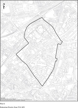
14.8 The core of the City Centre will be declared a pedestrian priority zone. The intention is to create a zone, broadly bounded by Southernhay, New North Road, the Waterloo line, Queen Street, Paul Street, North Street and South Street, which gives pedestrians real priority (see Plan 6). Within this boundary pedestrians will have priority through a range of measures:
[Click to see larger image in a pop-up window]
Plan 6: Pedestrian Priority Zone T10, KP1
14.9 The long term future of buses in the City Centre will be the subject of further assessment. Sidwell Street, Fore Street and South Street should continue to be key corridors for buses with quality interchange facilities for passengers. The routeing of buses through the High Street is detrimental to the pedestrian environment in this area. The aim is to reduce the impact of buses and their effect on air quality, by reducing the number of vehicles and the length of time spent at stops. Detailed proposals will be developed through a revised Bus Quality Partnership to achieve this. In the long term the City Council wishes to create a vehicle free High Street for a significant part of the day.
14.10 A phased programme of physical improvements (paving, planting and street furniture) will be implemented with priority given to High Street and links through to Castle Street and Rougemont Gardens/Castle (see 6.20).
KP1: A PEDESTRIAN PRIORITY ZONE WILL BE ESTABLISHED IN THE CORE OF THE CITY CENTRE WITHIN WHICH TIGHT DAY TIME VEHICLE ACCESS RESTRICTIONS WILL APPLY.
14.11 The refurbishment/redevelopment of this area to provide a net gain of approximately 20,000 sq. metres net additional durable floorspace is a key element in the future prosperity of the City Centre and represents the most realistic defence against out-of-town shopping (see 5.8 - 5.12). Being centrally located close to the High Street it provides an opportunity to add depth to the prime shopping area without adversely affecting pedestrian flows. A range of retail sizes should be provided together with housing, leisure and community uses. Views of the Cathedral along Princesshay and from Bedford Street must be retained and improved urban spaces for pedestrians created. Particular care must be taken to protect the historic setting of the site. The proposals should extend existing pedestrianised areas so that the whole of the area between High Street, Paris Street, Cathedral Close and Post Office Street would be almost entirely vehicle free. Provision should be made for shopmobility.
KP2: THE REFURBISHMENT AND/OR REDEVELOPMENT OF LAND AT PRINCESSHAY/BEDFORD STREET IS PROPOSED FOR RETAIL, HOUSING, LEISURE, COMMUNITY USES AND SHORT STAY PUBLIC CAR PARKING . THE DEVELOPMENT SHOULD:
(a) INCLUDE A RANGE OF RETAIL UNIT SIZES;
(b) RETAIN VIEWS OF THE CATHEDRAL PARTICULARLY ALONG THE EXISTING ALIGNMENT OF PRINCESSHAY AND FROM BEDFORD STREET;
(c) PRESERVE OR ENHANCE THE SETTING OF THE CATHEDRAL;
(d) IMPROVE THE SETTING OF THE CITY WALL, ST. STEPHENS CHURCH AND ST. CATHERINE'S ALMSHOUSES;
(e) CREATE NEW PEDESTRIAN URBAN SPACES THROUGHOUT THE SITE;
(f) PROVIDE PEDESTRIAN LINKS TO AND FROM THE HIGH STREET, CATHEDRAL CLOSE AND SOUTHERNHAY GARDENS;
(g) SEGREGATE SERVICE TRAFFIC FROM PEDESTRIANS WHERE FEASIBLE BY THE PROVISION OF UNDERGROUND SERVICING SUBJECT TO THE PRESERVATION OF THE UNDERGROUND PASSAGES AND DETAILED ARCHAEOLOGICAL STUDY;
(h) REPLACE EXISTING SERVICE ARRANGEMENTS TO ADJOINING PROPERTIES;
(i) PROVIDE CYCLE PARKING AND A LINK TO THE EXISTING CYCLE NETWORK;
(j) RETAIN THE PUBLIC TOILETS OR REPLACE IN A CONVENIENT AND ACCESSIBLE LOCATION.
14.12 The area defined by Sidwell Street, Cheeke Street, London Inn Square Paris Street, the Bus and Coach Station and Summerland Street is a highly sustainable location which, once Princeshay is fully trading, warrants the preparation of a master plan to achieve a high quality mixed use scheme. A comprehensive approach to its redevelopment is essential.
14.13 The site provides the best location in the City for commercial leisure facilities because of its close proximity to the primary shopping area of the City Centre, good public transport connections and proximity to public parking. A multiplex cinema and a nightclub would be justified by the existing demand. Other leisure facilities such as a health and fitness centre and family entertainment centre might be introduced as well as restaurants and public houses supporting a commercial leisure uses (see 5.39-5.52). The scheme must ensure that the bus station is well located to provide an effective bus network and is substantially enhanced. The potential for retail development is governed by the shopping policies of the Local Plan and the criteria of Policy KP3. In view of the adjoining uses, the housing should be restricted to non-family accommodation.
14.14 The site is prominent from the east from which direction it is seen as an integral part of the City Centre. Accordingly a good quality design is essential. Improvements to pedestrian access will be required especially across the heavily trafficked Paris Street which separates the site from the primary shopping area and the Civic Centre car park and also from Sidwell Street and the King William Street car park. Detailed proposals which extend the development area will be considered on their merits. The bus maintenance depot could be included if a satisfactory alternative location can be found for it. Part of the nearby Triangle car park may be used for bus layover to facilitate the development. Some short stay car parking spaces will be provided on the Bus and Coach Station site to replace the Bampfylde Street car park and compensate for the loss of spaces at the Triangle. The Council may seek to exercise its compulsory purchase powers for the purpose of site assembly.
KP3: COMPREHENSIVE REDEVELOPMENT OF THE BUS STATION/SIDWELL STREET/PARIS STREET IS PROPOSED, REFLECTING ITS STRATEGIC AND HIGHLY SUSTAINABLE LOCATION. THE DEVELOPMENT SHOULD PROVIDE AN ENHANCED BUS STATION, COMMERCIAL LEISURE FACILITIES INCLUDING POTENTIALLY A MULTI-SCREEN CINEMA, RETAIL FLOORSPACE, AN EXTENDED STREET MARKET, SHORT-STAY PARKING AND POSSIBLY NON-FAMILY HOUSING.
THE AMOUNT OF RETAIL FLOORSPACE SHALL BE DETERMINED FOLLOWING AN ASSESSMENT OF CAPACITY AND DEMAND AFTER THE IMPACT OF THE PRINCESSHAY DEVELOPMENT HAS BEEN ASSESSED. SUCH RETAIL DEVELOPMENT SHALL NOT HARM THE VIABILITY AND VITALITY OF THE CITY CENTRE AS A WHOLE.
THE DEVELOPMENT SHOULD:
(a) MAKE A POSITIVE CONTRIBUTION TO THE ENHANCEMENT OF THIS PROMINENT AREA OF CITY CENTRE TOWNSCAPE;
(b) BE FULLY INTEGRATED INTO THE CENTRAL SHOPPING AREA AND PRINCESSHAY AND HAVE HIGH QUALITY ACTIVE FRONTAGES WHICH FACE SURROUNDING STREETS;
(c) IMPROVE PERMEABILITY AND THE SAFETY AND CONVENIENCE OF PEDESTRIAN ACCESS TO THE SITE ESPECIALLY ACROSS PARIS STREET FROM THE PRIMARY SHOPPING AREA AND PRINCESSHAY TO/FROM THE PUBLIC TRANSPORT INTERCHANGE AND KING WILLIAM STREET CAR PARK AND,
(d) MAINTAIN A CYCLE ROUTE THROUGH THE SITE FROM PARIS STREET TO SUMMERLAND STREET.
14.15 The Station Yard area, which adjoins Central Station and the Waterloo rail line, is proposed for office development and for housing although careful design will be required to create an acceptable residential environment. The site should also accommodate short stay car parking to take pressure off parking in the Guildhall area.
14.16 The design must reflect the location of the site within the City Centre conservation area. A high quality development would enhance the image of the City to travellers arriving at Central Station. The scheme should be designed to create an enclosed streetscape appropriate to the urban form of the City Centre. Buildings facing onto New North Road should fit into the grain of the area by creating street form and active street frontage. Pedestrian access should be provided onto the Central Station railway platform from Queen Street.
KP4: LAND AT STATION YARD, QUEEN STREET IS PROPOSED FOR OFFICE DEVELOPMENT AND SHORT-STAY PUBLIC CAR PARKING AND FOR HOUSING PROVIDED THAT AN ACCEPTABLE RESIDENTIAL ENVIRONMENT CAN BE ACHIEVED. THE DEVELOPMENT SHOULD:
(a) MAKE A POSITIVE CONTRIBUTION TO THE ENHANCEMENT OF THE TOWNSCAPE AND THE SURROUNDING CONSERVATION AREA;
(b) CREATE AN ACTIVE STREET FRONTAGE ALONG NEW NORTH ROAD;
(c) PROVIDE ACCESS TO CENTRAL STATION FOR PEDESTRIANS AND FOR DISABLED PEOPLE.
14.17 A mixed redevelopment of land at St David's Station is proposed to enhance and take advantage of this strategic location. Appropriate uses are offices, student housing and small retail units which provide facilities appropriate for a local centre. Land will also be reserved on the forecourt of the Station to provide public transport interchange facilities with buses and to provide improved cycle parking and cycle links and a taxi rank.
14.18 The proposals must respect the character of St. David's Station and should aim to improve the station approach as a ‘gateway' to the City (see 6.8). This could be achieved by developing local centre retail units, with student housing above, facing the existing row of small shops along Isambard Way and creating a public square.
14.19 In the short term the development may be limited to the retail units and housing. In the long term there may be potential to achieve multi storey car parking and release some of the existing car parking land for offices and further housing.
KP5: LAND AT ST. DAVIDS STATION IS PROPOSED FOR OFFICE DEVELOPMENT, STUDENT HOUSING AND LOCAL CENTRE RETAIL UNITS. THE DEVELOPMENT SHOULD:
(a) MAINTAIN THE EXISTING LEVEL OF PARKING PROVISION FOR RAIL USERS;
(b) PROVIDE PUBLIC TRANSPORT INTERCHANGE FACILITIES, IMPROVED CYCLE PARKING AND CYCLE LINKS AND A TAXI RANK;
(c) ENHANCE THE STATION APPROACH AS A ‘GATEWAY' TO THE CITY.
14.20 The proposals for the Quay and the Canal Basin area are at the heart of the Council's strategy to promote tourism and diversify the range of attractions. The Quay area, which contains one of the finest groups of listed buildings in the City, including the 17th Century Customs House and the 19th Century warehouses, has experienced gradual improvement over the past 20 years. Footbridges have been built and refurbished over the waterways and access improved with the development of the Cathedral and Quay car park. Old industrial buildings have been converted to tourist use as restaurants, public houses and speciality shops including antique and craft outlets. The area is used as a starting point for walking, cycling and canoeing excursions along the Valley Park, supporting specialist hire and retail facilities.
14.21 The proposals envisage a wide mix of developments and activities over a substantial area incorporating the Quay, Cricklepit, Canal Basin and Water Lane/Canal Banks area. Proposed uses include housing (see H3: Site 10), visitor attractions, outdoor leisure facilities and restaurants supported by shops, craft workshops and hotel/hostel accommodation. Leisure uses which are closely associated with the river, the canal and the Riverside Valley Park will be especially appropriate, including water sports along the river and canal frontages. Up to 1,200 sq. metres net (1,700 sq. metres gross) of specialist retailing will be permitted provided that there is no single large space user.
(i) Quay
14.22 To maintain the ambience of the Quay area and protect its primary function as a heritage, leisure and restaurant quarter, permission will not be granted for night clubs or amusement arcades. Shops will only be permitted where they are ancillary to visitor attractions or leisure uses. Ancillary office space or housing will only be permitted on upper floors although a small hotel/hostel accommodation for visitors will be acceptable. All works to architecturally and historically important buildings must respect their existing appearance and character. Any redevelopment must be appropriate in scale, materials and overall character to that of the area as a whole.
(ii) Cricklepit
14.23 The Cricklepit site lies astride two medieval leats near the historic quayside, immediately below the Roman city wall. It is of considerable historic interest and contains important remains of the City's industrial past, particularly of the milling and woollen industries. Following a fire in 1999, the Council and other partners have facilitated the repair of Cricklepit Mill, which will culminate in the restoration of the internal mill wheel and machinery to working order. The mill building has planning permission for office use, with an element of interpretation and retail, and there is the potential for sensitively designed new build to accommodate further office, interpretation/education, and related uses. A Foyer scheme, to provide residential accommodation and training for young people, has also been developed on the site of the Lower Mills, and includes the reconstructed former 18 th century cloth drying house, a unique survival in Devon.
(iii) Canal Basin
14.24 A master plan has been prepared to promote the revitalisation of the area around the Basin. The site includes two listed warehouses and a nearby former electricity works, all of which are currently vacant. The restoration of these buildings and their re-use, together with adjoining land, is proposed to provide major visitor attractions and facilities for visitors. Redevelopment of adjacent areas is proposed for water related leisure uses and supporting restaurants, shops and craft workshops. Offices and housing are a possibility on upper floors. An area for boat laying-up activities will be retained within the Canal Basin development scheme.
(iv) Water Lane Area
14.25 In recent years there has been a trend for industry in the Water Lane area to relocate which has created opportunities to allow a number of sites to be developed for housing. Where sites come forward for development along the canalside the provision of leisure and ancillary activities will be promoted where appropriate and viable. Alternatively, housing will be permitted provided there is scope to introduce landscape features or open space as a buffer between housing and existing industry where this is considered to be necessary.
14.26 Where industry, which is located away from the waterside, wishes to remain the Council will support the improvement, refurbishment and redevelopment of existing industrial premises for continued employment use where, in view of current problems and having regard to the character of the area, they are accompanied by environmental improvements. These improvements can take many forms including the replacement of obnoxious uses by more environmentally acceptable uses and a reduction in pollution and traffic as well as enhancement of the surroundings through landscape works, use of sympathetic materials and sensitive building design.
14.27 Within this primarily industrial area the residential development of small sites would not normally be appropriate. However, if sites could be amalgamated to allow for comprehensive development, a wider range of uses, including housing, would be favourably considered provided this was compatible with other land uses, including industry, and incorporated any necessary buffer areas or uses.
(v) Canal Banks
14.28 The provision of a camp site for tents at Grace Road playing fields will be considered.
(vi) Access
14.29 Regeneration is linked to improving the accessibility of the area and the Council may seek financial support from prospective developers. Over the years, improvements have been made with a bus link to the Quayside, a new bridge over the Exe for pedestrians and provision of cycle routes and a bus only link through Tan Lane. However, there is increasing congestion getting in and out of Haven Banks and conflict between residential and industrial traffic.
14.30 Improved pedestrian connections with the City Centre and nearby car parks and better public transport connections to the City Centre and park and ride sites are particularly necessary. A road link is proposed from Alphinbrook Road to Water Lane to improve local and bus access. A road link connecting Water Lane to Haven Road via the Haven Road car park is also proposed as a means of reducing traffic in Haven Road and enabling the diversion of the Matford park and ride service to include a stop at the Basin. These improvements will require raising the weight limit on the railway bridge adjoining the Water Lane tip and establishing a control to prevent vehicles other than buses from using it as a through route. Bus priority measures from Haven Road onto Alphington Street will also be required. The implementation of the national cycle network through the area will improve cycle links (see 9.28) but footpath connections from the Haven Road car park to the Basin must also be improved.
KP6: THE DEVELOPMENT OF A MIX OF TOURIST, LEISURE, HOUSING, EMPLOYMENT AND SPECIALIST RETAILING USES IS PROPOSED AT THE QUAY, CANAL BASIN AND WATER LANE AREAS TO INCLUDE:
(i) THE RESTORATION AND ADAPTATION OF HISTORIC BUILDINGS AND THE REDEVELOPMENT OF UNDERUSED SITES IN THE QUAY AND CANAL BASIN AREA TO PROVIDE VISITOR ATTRACTIONS, OUTDOOR LEISURE FACILITIES AND RESTAURANTS SUPPORTED BY SHOPS, CRAFT WORKSHOPS AND HOTEL/HOSTEL ACCOMMODATION;
(ii) LEISURE AND HOUSING ALONG THE CANALSIDE;
(iii) HOUSING AND EMPLOYMENT IN THE WATER LANE AREA PROVIDED THAT THE PROPOSALS PROTECT THE AMENITY OF RESIDENTS AND DO NOT INHIBIT EXISTING INDUSTRY;
(iv) BOAT LAYING-UP FACILITIES;
(v) CAMP SITE AND ASSOCIATED FACILITIES;
(vi) PROVISION OF THE NATIONAL CYCLE ROUTE THROUGH THE AREA;
(vii) A FINANCIAL CONTRIBUTION TO THE PROVISION OF:
(a) A ROAD LINK FROM ALPHINBROOK ROAD TO WATER LANE AND FROM WATER LANE TO HAVEN ROAD VIA THE HAVEN ROAD CAR PARK, INCLUDING TRAFFIC MANAGEMENT/CALMING MEASURES LIMITING THROUGH VEHICLE ACCESS TO BUSES AND CYCLES ONLY;
(b) BUS PRIORITY MEASURES FROM HAVEN ROAD ONTO ALPHINGTON STREET, AND
(c) IMPROVED PEDESTRIAN AND CYCLE LINKS AND SIGNING.
THE DEVELOPMENT SHOULD HAVE REGARD TO RELEVANT CRITERIA IN POLICIES C1-C3, C5, DG1-DG4 AND SUPPLEMENTARY PLANNING GUIDANCE/DOCUMENTS RELATING TO THE AREA.
14.31 The area to the east of the outer bypass offers a key opportunity to develop the City's role as an employment and housing centre with good public transport links. Although the use of previously-developed land within the City will be maximised there are insufficient opportunities to meet the identified demand (see Sections 3 and 4). The peripheral expansion of the City is constrained to the north, west and south (see Section 11). Land to the east is attractive to investment because of its good access to the motorway system and to the A30, but is also constrained by significant areas of open land (see 11.4-11.14) which contribute to the landscape setting of the City.
14.32 This area is proposed as a mixed use, public transport based, development area which is comprehensively planned and fully integrates housing, employment, retail, community, education, social and health care and leisure and transport facilities. This includes a new school at Hill Barton; employment development to the east and west of Exeter Business Park and at Sowton 30, off Sidmouth Road; housing and retail warehousing at Digby; housing development north of Old Rydon Lane and a strategic employment site south of the A379; and housing development at the RNSD, between Old Rydon Lane and Topsham Road.
14.33 The proposals are brought forward within the following broad spatial framework (see Plan 7):
(i) major employment development located close to the motorway junctions, along the main radial routes;
(ii) strong local service centres, which may include schools, community facilities and local shops, located within the centre of developments so as to function as a focal point of the local community and well related to public transport routes;
(iii) highest density housing grouped around the local service centres and adjacent to the main public transport routes;
(iv) road link from Honiton Road to Pinhoe Road to serve Exeter Business Park and Sowton, enable employment land to be released and reduce traffic in nearby residential roads (see T14);
(v) an eastern fringe bus route linking employment development to the south of the City at Matford with the new employment, housing, retail and education proposals between the outer bypass and the motorway and connecting through to Pinhoe via the new road link;
(vi) direct, safe and convenient pedestrian and cycle links within and between the proposed employment and housing areas and with adjoining areas;
(vii) integrated transport provision linking the development proposals along the eastern fringe with the wider Exeter area and in particular with the employment development at Skypark, Exeter Airport expansion and new settlement in the Rockbeare area – to include improved train frequencies on the Exeter to Waterloo line, a railway station at the new settlement and increased capacity of rail services on the Exeter to Exmouth line.
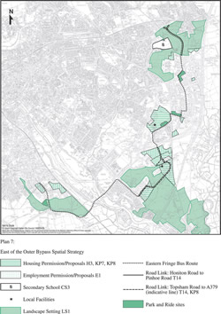
[Click to see larger image in a pop-up window]
Plan 7: East of the Outer Bypass Spatial Strategy
14.34 The comprehensive development of all the land between the Sidmouth Road, outer bypass, A379 and the railway line is proposed. The majority of the former Digby Hospital land, adjoining the A379, has been developed for housing, including the conversion of the hospital to flats. A Tesco foodstore and adjoining retail warehouse park has been developed in the south western corner of the site and a rail halt has been provided adjoining the Exeter to Exmouth rail line, together with a park and ride site nearby. The allocation of the remainder of the Digby area for housing and associated facilities is proposed. Around 600 dwellings may be possible. The Digby planning brief provides guidance but is updated by this Plan.
14.35 Since the development will add significantly to pressures on the local area, including schools, it must be supported by the provision of appropriate community facilities and by a new primary school for which developer contributions will be sought. The community facilities, including open space, should be located so as to function as a focal point. Developers will be required to provide a co-ordinated framework or master plan which explains how they propose to create a distinct new settlement and a clear sense of place. Typically suburban open plan, motor vehicle and highway dominated, arrangements should be avoided.
14.36 Access to the development area should be provided through an internal highway system which links access points from Rydon Lane, at the junction with Peninsula House, from Russell Way and from Sidmouth Road, to create a permeable layout. In view of the pressures on the highway network in this area provision for alternatives to the car will be essential, to include an efficient through route for buses and an integrated pedestrian and cycle network.
KP7: LAND AT DIGBY IS PROPOSED FOR HOUSING, A PRIMARY SCHOOL, COMMUNITY FACILITIES, AND A HIGH QUALITY RETAIL PARK OF UP TO 9,290 SQ METRES GROSS RETAIL WAREHOUSE FLOORSPACE. THE DEVELOPMENT SHOULD BE BASED ON A CLEAR, INTEGRATED, URBAN AND LANDSCAPE DESIGN CONCEPT FOR THE AREA AND SHOULD INCLUDE:
(a) A CO-ORDINATED RESIDENTIAL LAYOUT WHICH CREATES A DISTINCT IDENTITY AND SENSE OF PLACE AND AVOIDS TYPICALLY SUBURBAN OPEN PLAN, MOTOR VEHICLE AND HIGHWAY DOMINATED, ARRANGEMENTS;
(b) THE PROVISION OF OPEN SPACE, COMMUNITY FACILITIES AND SCHOOL IN A CENTRAL LOCATION SO THAT THEY FUNCTION AS A FOCAL POINT OF THE NEW COMMUNITY.
(c) A LAYOUT OF RETAIL BUILDINGS AND SPACES WHICH IS WELL RELATED TO THE TESCO FOODSTORE AND WHICH CREATES AN ATTRACTIVE PEDESTRIAN ENVIRONMENT WITHIN A LANDSCAPE SETTING;
(d) VEHICLE ACCESS FROM RYDON LANE AT THE JUNCTION WITH PENINSULA HOUSE; FROM RUSSELL WAY; AND FROM SIDMOUTH ROAD;
(e) AN INTERNAL HIGHWAY SYSTEM, LINKING THE THREE ACCESS POINTS, TO PROVIDE A PERMEABLE LAYOUT;
(f) MAXIMUM PROVISION FOR PUBLIC TRANSPORT, TO INCLUDE AN EFFICIENT THROUGH ROUTE FOR BUSES;
(g) THE IMPLEMENTATION OF AN INTEGRATED PEDESTRIAN AND CYCLE NETWORK TO LINK TO SURROUNDING DEVELOPMENT.
14.37 Housing development is proposed on land north of Old Rydon Lane between St. Bridgets Nursery and the railway line; on the upper site of the Royal Naval Stores Depot and adjoining land to the east of Newcourt House; and on the lower site of the Royal Naval Stores Depot and adjoining land to the east (see H3: Sites 12, 13 and 14) to provide around 900 dwellings. Land immediately to the south of the A379 is proposed for a Science Park (see E1: Site1).
14.38 The development of the Newcourt area provides an opportunity to create an attractive working and living environment based around a substantial centrally located community focus which should include a primary school, local shops, open space and community facilities. Particularly important is the need to ensure that maximum provision is made for public transport, pedestrians and cyclists and that the amenity of the existing local residents is preserved. Developers will be required to base their proposals on an integrated urban and landscape design concept for this mixed employment and housing area. The residential layout must create a distinct identity and sense of place and avoid typically suburban, open plan, motor vehicle and highway dominated arrangements.
14.39 The RNSD is a brownfield site but development of the land north of Old Rydon Lane will involve the loss of pleasant rolling agricultural land most of which is Grade 1. It is characterised by a patchwork of large fields, mainly arable, divided by low hedgerows and located on a long gentle slope. However, in comparison with other open land around the City, it is relatively undistinguished.
14.40 Access to the Newcourt area will be from the A379 and from Topsham Road. The road linking the A379 and Topsham Road will be subject to bus compatible traffic calming measures and will form part of the eastern fringe bus route. Housing development on the RNSD, served off Topsham Road, will be restricted to a maximum of 200 dwellings until the link road to the A379 is open to the public.
KP8: LAND IN THE NEWCOURT AREA IS PROPOSED FOR HOUSING AND EMPLOYMENT DEVELOPMENT SUPPORTED BY A NEIGHBOURHOOD CENTRE WHICH SHOULD INCLUDE A PRIMARY SCHOOL, LOCAL SHOPS, OPEN SPACE AND COMMUNITY FACILITIES . THE DEVELOPMENT SHOULD BE BASED ON A CLEAR, INTEGRATED, URBAN AND LANDSCAPE DESIGN CONCEPT FOR THE AREA AND SHOULD INCLUDE:
(a) A CO-ORDINATED RESIDENTIAL LAYOUT WHICH CREATES A DISTINCT IDENTITY AND SENSE OF PLACE AND AVOIDS TYPICALLY SUBURBAN OPEN PLAN, MOTOR VEHICLE AND HIGHWAY DOMINATED, ARRANGEMENTS;
(b) THE SITING OF THE NEIGHBOURHOOD CENTRE IN A CENTRAL LOCATION SO THAT IT FUNCTIONS AS A FOCAL POINT OF THE NEW COMMUNITY;
( c ) THE PRESERVATION OF THE AMENITY OF LOCAL RESIDENTS;
(d) VEHICLE ACCESS TO THE LAND NORTH OF OLD RYDON LANE FROM THE A379 AND TO THE UPPER DEPOT SITE FROM TOPSHAM ROAD AND, AFTER COMPLETION OF THE 200 TH DWELLING ON THE UPPER SITE, TO THE WHOLE OF THE DEVELOPMENT IN THIS PROPOSAL FROM BOTH THE A379 AND TOPSHAM ROAD, INCORPORATING BUS-COMPATIBLE TRAFFIC CALMING MEASURES ALONG THE ROAD LINKING THE UPPER AND LOWER SITES;
(e) MAXIMUM PROVISION FOR PUBLIC TRANSPORT TO INCLUDE A BUS LANE ALONG TOPSHAM ROAD FROM THE DEVELOPMENT ENTRANCE TO COUNTESS WEAR ROUNDABOUT, AN EFFICIENT THROUGH ROUTE FOR BUSES AND INVESTIGATION OF IMPROVEMENTS TO RAIL INFRASTRUCTURE;
(f) THE IMPLEMENTATION OF AN INTEGRATED PEDESTRIAN AND CYCLE NETWORK;
(g) THE REMOVAL OF WAREHOUSES ON THE MIDDLE DEPOT SITE.
^ Top | < Previous
| Next >